These objects are replicas of Norse navigation tools, used by sailors to find their latitude before the sextant and Global Positioning System (GPS) were invented. Tools like these were used in order to figure out where in the sea a sailor was. Traveling by land, explorers can use nature, roads, paths, mile markers and landmarks that make it easier to get one from place to another. However, terrain that has few, or no, landmarks like the desert or the sea are difficult to navigate. Using latitude and longitude helps sailors and explorers determine how far they are from their starting point. Using latitude and longitude can help sailors reach their destination correctly, give or take by a few miles.
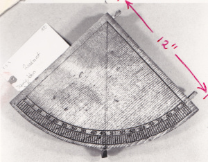
A quadrant, was used to measure the altitude or angle above the horizon of a star, this helped sailors calculate their latitude, or the lines on a map going from West to East. Sailors in the northern hemisphere would use the North Star, the brightest star, to find their latitude at night because it is directly over the north celestial pole and never sets. They would measure the height of the star when they started their journey and then they would compare it to the measurements as they traveled with a quadrant. They measured the height of the star from the horizon by placing the quadrant near their eye and the weight will fall to the correct degree.
Other tools used by sailors, Vikings mostly, are the pelorus and the sun shadow board. A pelorus resembles a mariner’s compass, except there is no magnetic needle. This tool was used to measure latitude during the day time. The needle in the middle of the base, or the gnomen, cast a shadow and that shadow was looked at when the sun was in the noon position. A sun shadow board was placed in a bowl of water and was used to calculate the ships latitude and direction. The shadow and the little circles on the base told the sailors whether they were in the latitude they wanted to be in.
Longitude, or the lines on a map going from North to South, was found using the sun and time. However this calculation was more difficult because, unlike today, time was not kept universally and there wasn’t a way to check that your clock was set correctly. Also, clocks and watches needed to be wound up, therefore the watches slowed down and lost time every day as the internal clockworks ran out of energy. They calculated their longitude by knowing what time the sun was in a certain position in the sky at the Prime Meridian, which is at the Royal Observatory in Greenwich, United Kingdom. By carrying a clock set to the time at the Prime Meridian, travelers then could compare what time the sun reached that set position in their location. Each hour of difference roughly equals a 15 degree change in longitude.
Many sailors from the 1500s to around the 19th century were explorers. One explorer by the name of Alonso Álvarez de Piñeda, a Spanish explorer, was the first known European to map the Texas coastline. Many European explorers did not know where they ended up because they did not know how to calculate both their latitude and longitude. Many shipwrecked on unknown shores, claiming it and then not being able to find it again to colonize it. A French explorer who tried to claim Texas in the name of the French by establishing Fort St. Louis was Robert Cavelier, Sieur de LaSalle. Once time became universally synchronized and sailors and land explorers knew how to calculate their latitude and longitude they could explore land more accurately and then find it again when they were starting to colonize it.